Long-time coastal volunteer John Hatch has been using Photomon since 2020 to capture images from fixed vantage points along the Lancelin foreshore. In May this year, he returned to one of his monitoring sites at Hinchcliffe Hill and was faced with a confronting scene.
His comparison photos told a clear story – in just five years, the dunes had receded roughly 25 metres. Even more interesting, this was the product not of an extreme weather event, but of long-term, relentless wear on the coastline.
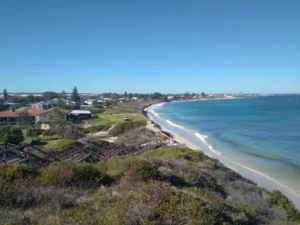
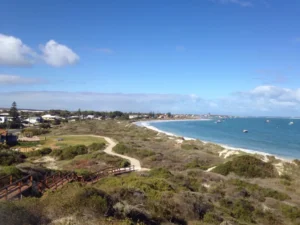
25 Metres in 5 Years
Photo credit: John Hatch
From years of monitoring, John has seen that erosion is often most pronounced where built infrastructure has interfered with the natural dune systems. While paths, lawns, and buildings provide public amenity, they also disrupt the dunes’ natural processes of shifting and recovery. Instead of relying on constructed barriers, John believes the best solution lies in allowing dunes to do what they do best – regenerate and protect the coastline naturally.
Stories like John’s remind us just how valuable citizen science can be in managing natural resources. By making observations and getting involved, community members can play a critical role in helping coastal managers and researchers understand and respond to the challenges facing our coastline.