Salinity is one of the most significant land degradation issues affecting the Northern Agricultural Region, with major ecological and agricultural consequences particularly to the Eucalypt Woodlands of WA’s Wheatbelt TEC (Threatened Ecological Community).
Extensive land clearing for broadacre cropping and grazing has disrupted natural hydrological processes. The loss of the established perennial native vegetation has allowed rainfall to infiltrate more deeply into soils, raising groundwater levels and mobilising naturally occurring salts stored in the water table. As groundwater rises to the surface or near-surface layers, it brings dissolved salts with it, leading to soil and water salinisation.

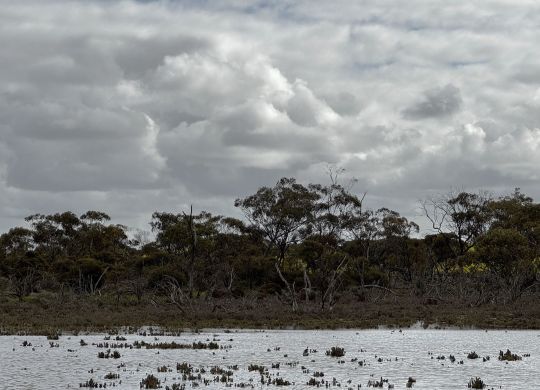
Salinity in the Northern Agricultural Region
Current estimates suggest that over 1 million hectares of agricultural land across the Wheatbelt are at risk[2], with projections of continued expansion unless management and revegetation efforts are widely adopted. In addition to economic impacts to farming, salinity severely impacts some of the most precious natural communities across the wheatbelt. It is common to see salt scars in the land marked by the skeletons of trees which once thrived in low lying wet areas.
The Wheatbelt Eucalypt Woodlands TEC
The Eucalypt Woodlands of the Western Australian Wheatbelt once covered vast areas of the Wheatbelt. They are one of the most iconic wheatbelt communities and provide critical habitat for a range of threatened flora and fauna.
Remnant patches of these woodlands are now highly fragmented due to agricultural clearing. Salinity is one of the greatest ongoing threats to their persistence due to their association with the low lying valley floors.
Salinity has had and continues to have a large impact on the Wheatbelt woodlands TEC, rising saline ground water disrupts the root systems causing tree mortality. This is accompanied by collapse of the understory which often has high sensitivity to salt levels.

Management
Addressing salinity in the NAR requires catchment-scale and site-specific approaches. There has been great investment and learning into how best to manage salinity to protect vegetation and arable areas.
Limiting build-up of surface water across the landscape is the key management tool. Unused surface water is the primary cause of aquifer recharge causing the saline water tables to rise. Stopping and utilising water before the low lying valleys is the most effective method of control. Successful techniques include[3]:
- Increased cropping / pasture water use efficiency
- Minor earthworks to manage surface flows
- Establishing vegetation corridors
Minimising stressors specific to native vegetation areas can help to enhance resilience through,
- Fencing to protect from grazing
- Establishing salt-tolerant buffer vegetation
- Weed and pest control

Proactive management can slow the spread of salinity reduce impacts on the Wheatbelt Eucalypt Woodlands TEC. Protecting these woodlands is not only critical for biodiversity conservation but also for maintaining one of Australia’s most iconic natural communities. Your local catchment council or NRM group will have resources available to help guide strategies for managing salinity.
This project is jointly funded by the Australian Government Natural Heritage Trust and NACC NRM, a member of the Commonwealth Regional Delivery Partners panel.
[1] MOORE CATCHMENT COUNCIL: Natural Resource Management information guide for the Moore River catchment Shires.
https://www.moorecatchment.org.au/wp-content/uploads/2020/03/Moore-nrm-shire-guide-March-2020-Web.pdf
[2] CSIRO: DRYLAND SALINISATION: A CHALLENGE FOR LAND AND WATER MANAGEMENT IN THE AUSTRALIAN LANDSCAPE. John Williams*, Glen R. Walker and Tom J. Hatton
[3]Conservation Commission of Western Australia: Salinity management in the south-west of Western Australia. https://www.conservation.wa.gov.au/sites/cpc/sites/default/files/final%20report%202014.pdf